
Documentation
Map Key
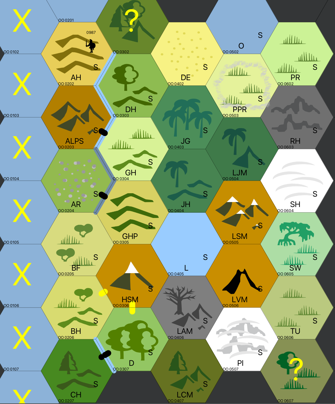
- 🎯 Hexes that your units have seen, but never actually entered, are marked with a large yellow X.
- 🎯 Hexes that scouts have entered have a small S near the right edge.
- 🎯 The map coordinates (eg PQ 0213) are displayed in the lower left corner of each hex.
- 🎯 Rivers are displayed as a blue line along the hex edge. Canals are displayed as a slightly darker blue line.
- 🎯 Your units are displayed as a black figure on the upper right edge. Other players' units are displayed as a red figure on the upper left edge. If there's only a single unit in the hex, then the unit's number is displayed. Otherwise, "clan" is displayed above the unit and the list of units is attached as a note to the figure.
- 🎯 Settlements are displayed as a black town icon in the center of the hex. The name of the settlement is displayed along the bottom edge of the hex. NB: If the settlement name looks like "L 1234", then there's a typo in your report that you should fix.
- 🎯 The yellow or black pillboxes connecting hexes represent passes or fords. NB: if only half a pillbox is visible, this usually means that the neighboring hex hasn't been entered.
- 🎯 Ocean and lakes can be hard to tell apart. You can ask OttoMap to change the color of the ocean to make it easier to see.
- 🎯 Units with wagons can't enter Swamp or Jungle Hill hexes. The report shows "Cannot Move Wagons into Swamp/Jungle Hill," which doesn't show the true terrain type. OttoMap will show a large yellow "?" in the hex until one of your units reports on the true terrain type.
Tile Mappings
| Short Code | Long Code | Worldographer Terrain |
|---|---|---|
| ALPS | Alps | Mountains |
| AR | Arid Tundra | Flat Moss |
| BF | Brush Flat | Hills Shrubland |
| BH | Brush Hills | Hills Shrubland |
| CH | Conifer Hills | Hills Forest Evergreen |
| D | Deciduous Forest | Flat Forest Deciduous Heavy |
| DE | Desert | Flat Desert Sandy |
| DH | Deciduous Hills | Hills Deciduous Forest |
| GH | Grassy Hill | Hills Grassland |
| GHP | Plateau Grassy Hill | Hills Grassy |
| HSM | High Snowy Mountains | Mountain Snowcapped |
| JG | Jungle | Flat Forest Jungle Heavy |
| JH | Jungle Hill | Hills Forest Jungle |
| L | Lake | Water Sea |
| LCM | Low Conifer Mountains | Mountains Forest Evergreen |
| LJM | Low Jungle Mountain | Mountain Forest Jungle |
| LSM | Low Snowy Mountains | Mountains Snowcapped |
| LVM | Low Volcano Mountains | Mountain Volcano Dormant |
| O | Ocean | Water Ocean |
| PI | Polar Ice | Mountains Glacier |
| PPR | Plateau Prairie | Flat Grasslands Poor |
| PR | Prairie | Flat Grazing Land |
| RH | Rocky Hill | Underdark Broken Lands |
| SH | Snow Hill | Flat Snowfields |
| SW | Swamp | Flat Swamp |
| TU | Tundra | Flat Steppe |